Monthly Archives: April 2019

A look back at the weekend tornadoes and the outlook for more this week.

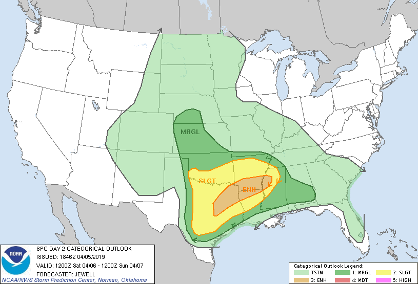
April 16, 2019, …  A look back at the weekend tornadoes and the outlook for more damaging storms this week. Below is the Day 01 convective outlook for Saturday April 13, 2019.

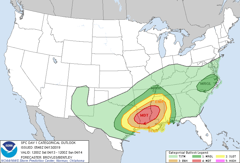
From that Day 01 outlook, SPC anticipated a very active Saturday:

“a regional outbreak of tornadoes could occur across parts of the moderate risk area”

An outbreak of tornadoes did in deed occur in and close to the moderate and enhanced risk areas.

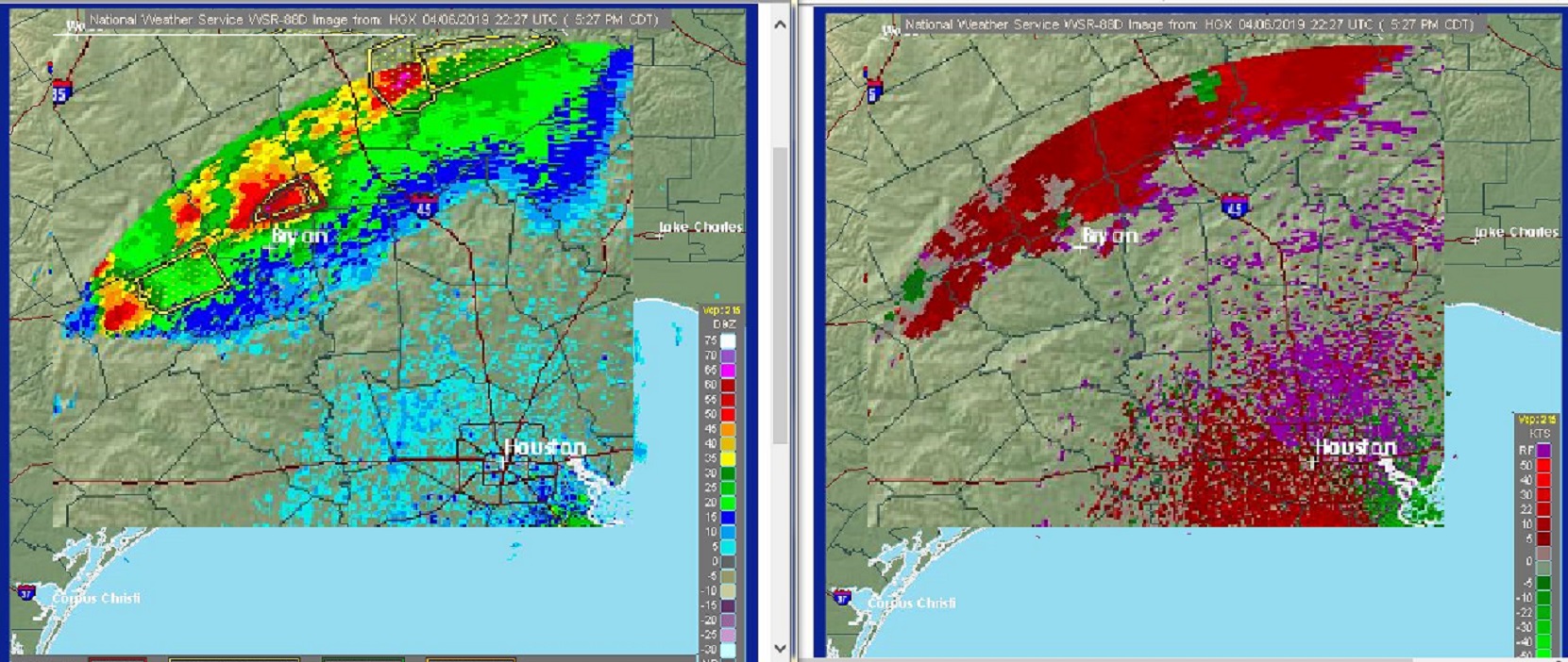
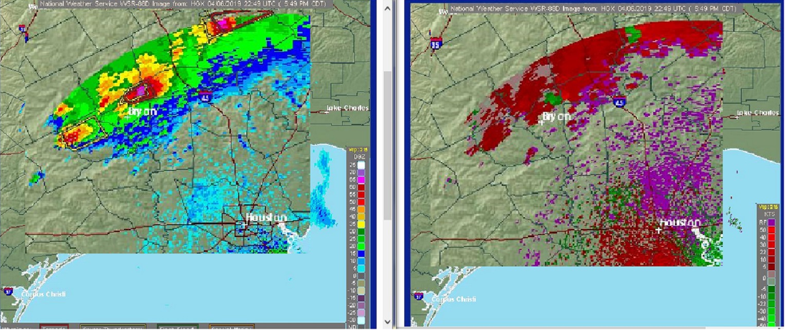
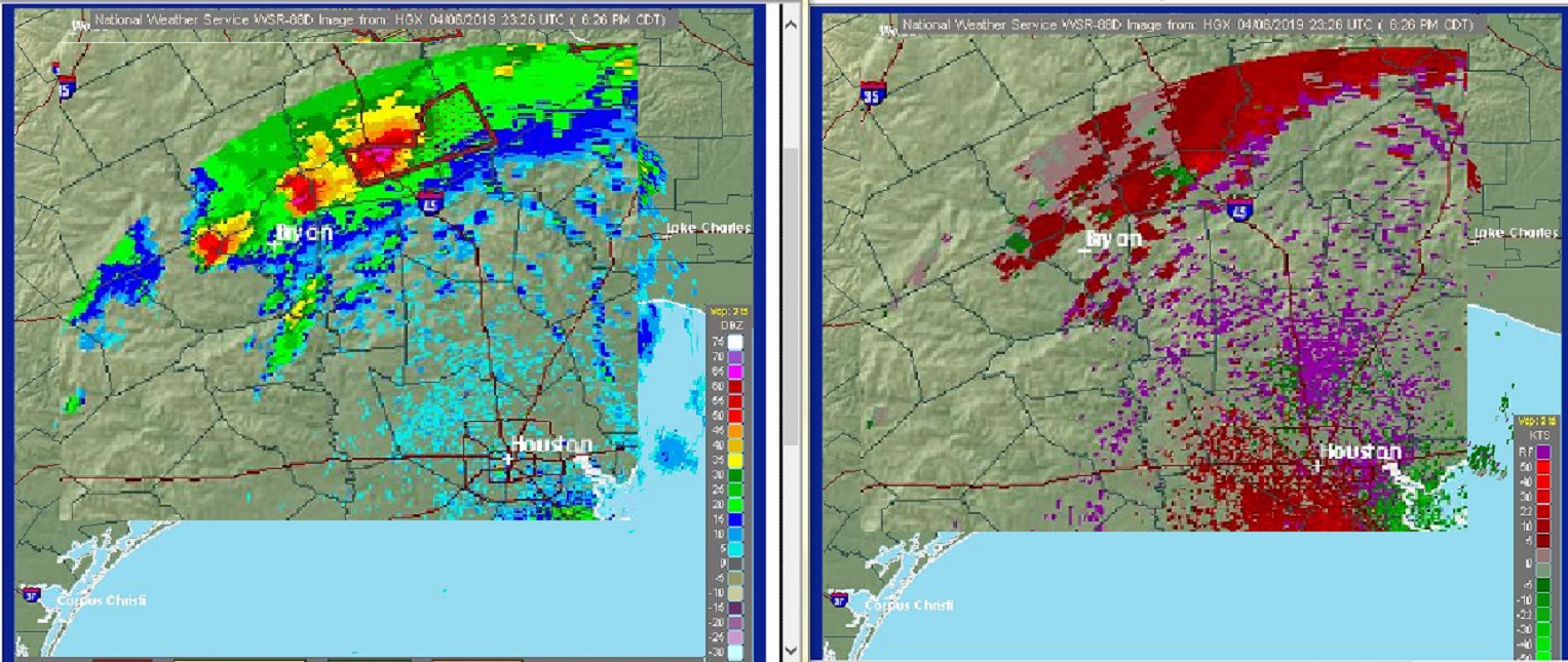
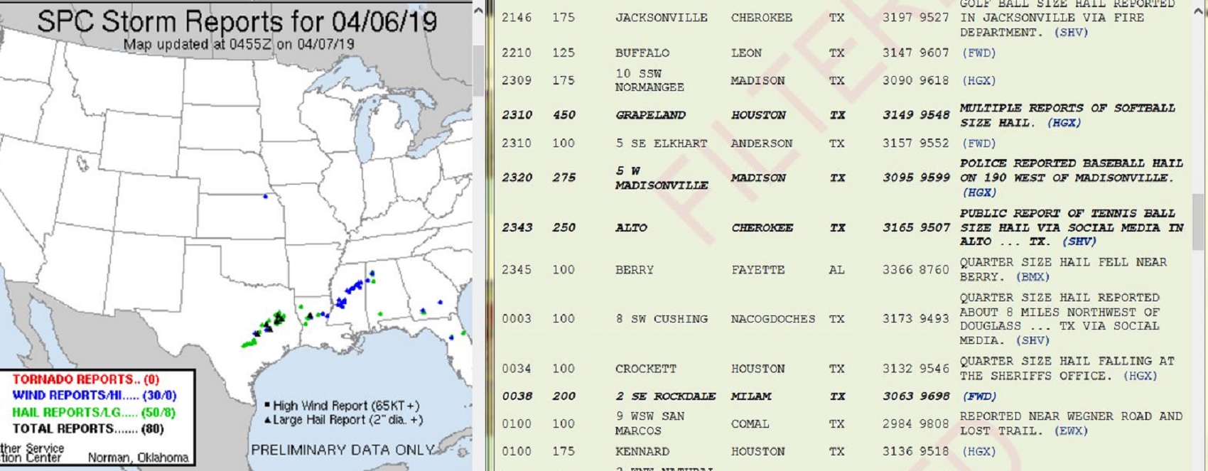
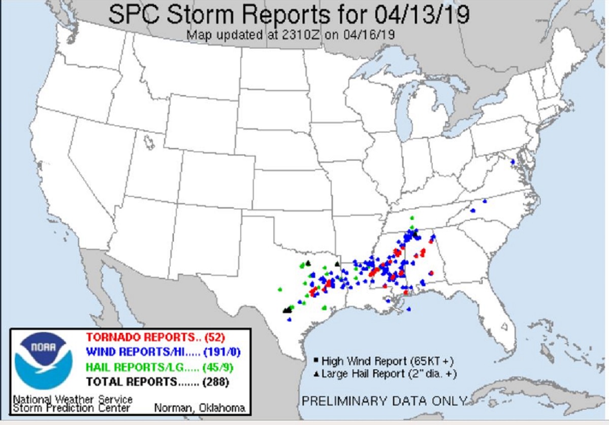
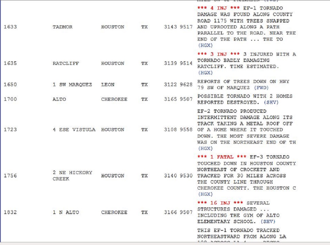
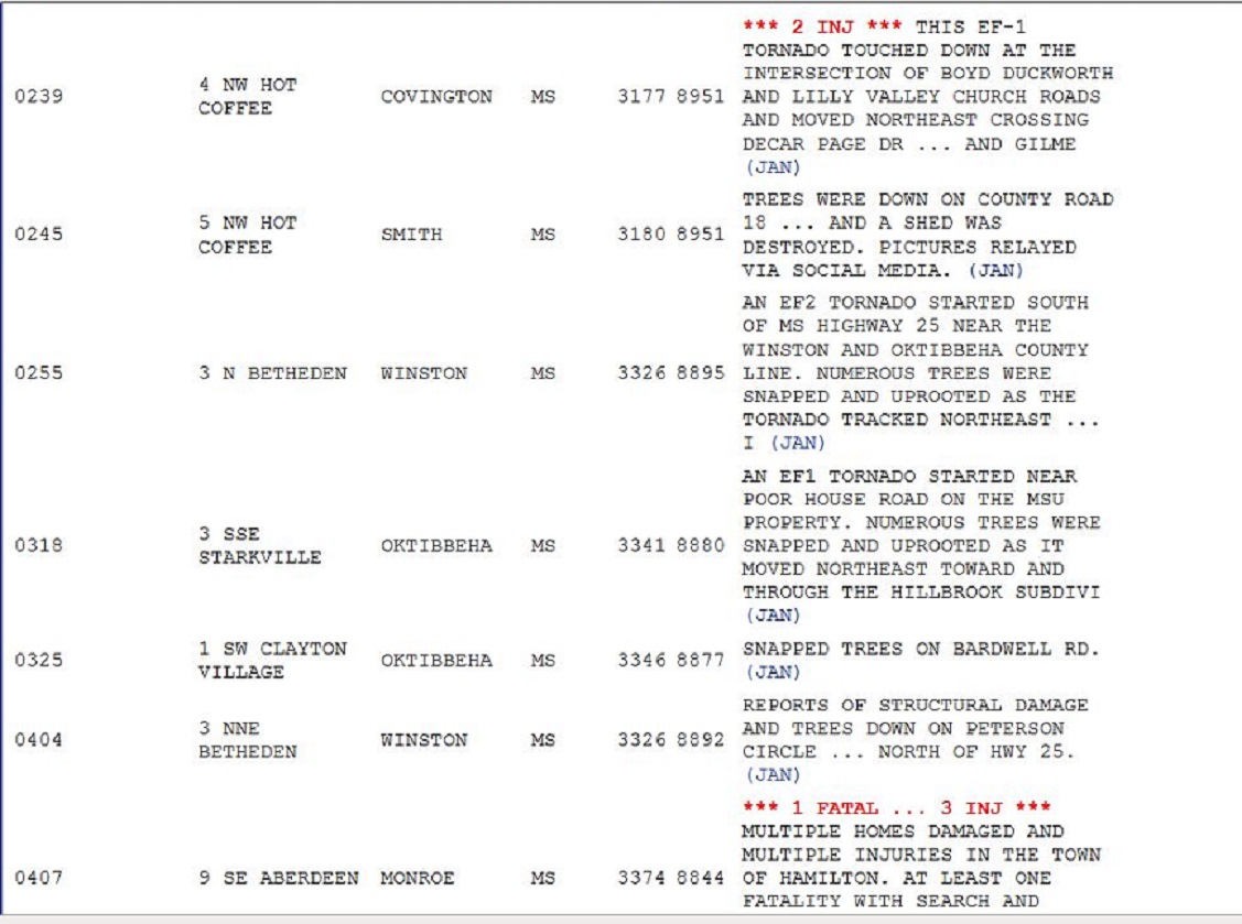
A few selected tornado reports from Saturday’s outbreak showing  approximate time (UTC) of the event as well as property damage, injuries and fatalities. Severe storms began early in the day across Texas and continued into the overnight across Mississippi and Alabama.

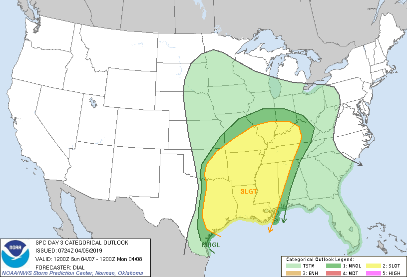
Below is the Day02 convective outlook for Wednesday April 17, 2019

“Steep lapse rates and long hodographs will favor large damaging hail.  Wind profiles
suggest less-than-optimal supercell/tornado environment. Still, robust storms capable of severe hail and damaging wind are likely.”

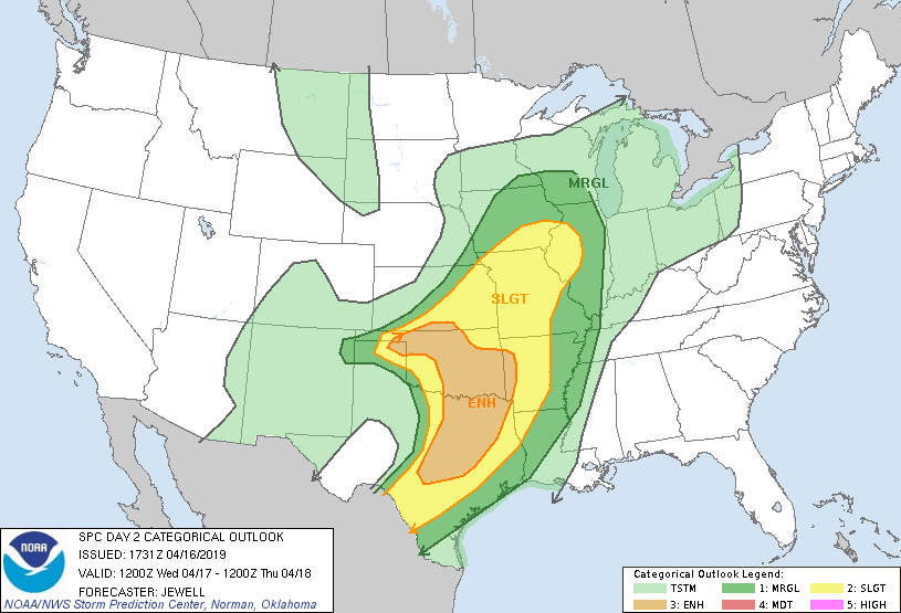
The enhanced risk is a little less certain than the moderate risk.  But more damaging storms are expected Wednesday and Thursday of this week across the central and southern  United States.

Remember you can watch the evolution of the storm system with the various products of the Storm Prediction Center (SPC) which can be found simply at,

https://www.spc.noaa.gov/

also monitor your local NWS office to keep up with actual specific storm warnings

NWS, …https://www.weather.gov/

NWS radar will help you track the damaging storms

Radar, …https://www.weather.gov/Radar

more active weather in the days ahead, stay alert

over and out

Wild Bill

Saturday April 13, 2019 A potential for long-track tornadoes

Saturday April 13, 2019  A potential for long-track tornadoes

Headline taken straight from SPCs Day 1 Convective Outlook discussion.

” A potential for long-track tornadoes
will be possible and a regional outbreak of tornadoes could occur
across parts of the moderate risk area.”

Serious stuff for Louisiana and Mississippi.  Be weather aware on this stormy day.

https://www.spc.noaa.gov/products/outlook/day1otlk.html


Wild Bill

Severe hail producing Texas thunderstorms

April 06, 2019  Radar presentation of severe hail producing Texas thunderstorms

Saturday April 06, 2019Houston (HGX ) 5:27pm CDT (22:27 UTC )

The precipitation frame on left shows thunderstorms with deep red and purple shading. This indicates large hail.  The frame to the right shows green/red couplets.  This indicates rotation.  Tornado Warnings were issued for several storms, but the story of the day appears to have been large hail.  Check some of the reports below.

Saturday April 06, 2019Houston (HGX ) 5:49pm CDT (22:49 UTC )

Saturday April 06, 2019Houston (HGX ) 6:26pm CDT (2326 UTC )

Day 2 Convective Outlook from Friday

Severe reports for Saturday mapped by SPC sitting beside some rather large hail reports including a listing of 450 at 2310UTC at Grapeland Texas.  The figure 450 is equal to 4 1/2 inches, or softball size hail.

more active weather in the days ahead, stay alert

over and out

Wild Bill

Convective Outlooks foreshadow a stormy weekend.

April 05, 2019 Convective Outlooks foreshadow a stormy weekend.

2 Day convective outlook for Saturday April 06, 2019

3 Day convective outlook for Sunday April 07, 2019

https://www.spc.noaa.gov/products/outlook/

You will need to check back with SPC over the weekend.  These outlooks will be revised and updated several times a day through the weekend event. On Saturday, the Day 2 outlook becomes Day1, and the Day3 outlook will become Day 2. If you reside in the yellow shaded areas for either Saturday and Sunday,  you need to monitor weather conditions with a heighten sense of awareness.  Damaging thunderstorms may produce straight line winds, large hail, and even a tornado.

SPC, …https://www.spc.noaa.gov/

NWS, …https://www.weather.gov/

Radar, …https://www.weather.gov/Radar

I will make an effort to update during the weekend as greatest risk areas become more defined.

Wild Bill

The spring thaw at Manzanita Lake in the Lassen Volcanic National Park

April 05, 2019  Webcam review of the variability of the spring thaw at Manzanita Lake in the Lassen Volcanic National Park.  This year the Lake has remained frozen over even into early April. The following webcam pictures compare the spring thaw of the last several years from 2019 back to 2014.

April 05, 2019     frozen                                                   April 05, 2018  thaw underway

April 04, 2017 thaw underway                                April 03, 2016  last of winter ice far end of lake

January 23, 2015 thaw in January                        February 17, 2014 thaw in progress

Since 2014  early April this year is the latest Manzanita Lake has remained fully frozen.  I see this as vivid evidence you can see  that the later half of the winter was quite cold even as far west as the Lassen Peak in Northern California.

Webcams retrieved from following Lassen Peak Volcanic National park website.

https://www.nps.gov/lavo/learn/photosmultimedia/webcams.htm

Below,  larger pictures of the above webcam snapshots.

April 05, 2019

April 05, 2018

April 04, 2017

April 03, 2016

January 23, 2015

February 17, 2014

I will revisit this subject  in the coming days as the thaw progresses.

Heads up, severe threat this weekend across the south central US. Please see the next blog post.

Wild Bill.